In the first post in this series, we discussed that knowing the direction of sunlight (or moonlight) has an enormous impact on your photograph, and suggested some fantastic apps that can help you plan ahead for where the light will be. In this post, we’ll take it to the next step, because knowing where the light will be assumes that the sun has a direct path to the subject of your photograph, and that the light is not filtered or completely blocked by cloud cover. Unfortunately, in addition to the “light,” we have to be aware of the weather.
There are over 800 weather apps in the iTunes store!!! You can have information on your iPhone or iPad that provides weather information in every conceivable way. Many of the programs are free, most of the “paid” apps cost $.99 – $2.99, with some more specialized programs and more expensive. When it comes to weather apps, I’m looking to answer some important questions:
1) What will the weather be when I’m on location shooting?
2) Are there any special considerations for equipment or clothing, because of very low or very high temperatures, rain, snow, wind, humidity, dew point, etc?
3) Will there be cloud cover, and if so, to what extent when on location shooting?
4) Will the weather change during the time when I’ll be shooting?
5) Are there any safety issues, such as flash floods, hurricanes, thunderstorms, lightning, hail, etc. that could be dangerous to me or jeopardize my equipment?
The answers to these questions will determine whether I go out shooting, what I wear, if I need protection for my gear, or if I need to shoot on another day or at another time. I’ve tried many weather programs, and as I mentioned, there are so many, that you want to carefully read the app features and reviews. Sometimes it isn’t just the features, but how the information is displayed and the app’s “user-friendliness.” I’m always looking for the ONE app that will accomplish everything I need, but I haven’t found it yet.
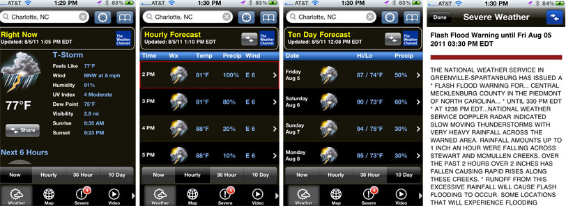
For general weather information (temperature, precipitation, humidity, dew point, wind, hourly predictions, 36 hours forecast, 10 day forecast, etc.), I use The Weather Channel MAX,a $3.99 app, although there are hundreds of others with similar features. The reviews for this app vary, but I’ve used it for a few years and like it. Here are sample screenshots of just a few of the screens:
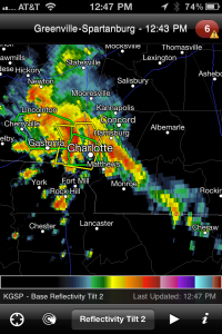
I have found RadarScope to VERY accurately show the areas of precipitation, severe thunderstorms, flash floods and tornadoes and you can put the radar in motion to get a sense of direction, speed and where the weather is going. There are many, many options for the type of radar display you’d like, and if you’re considering this app, view an excellent QuickTime demo of RadarScope on Base Velocity’s website at RadarScope Demo .
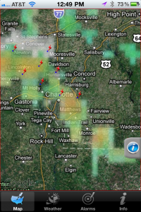
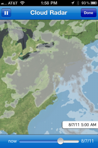
The last app for this post, Fahrenheit, is a good overall $.99 weather app, but what I especially like are its cloud cover maps. You can put all of Fahrenheit’s maps in motion, and you get a very good sense of the direction and speed of cloud movements. Before you buy Fahrenheit, check out the other weather apps you’re considering to see if any provide you with cloud cover information that is adequate for your needs.
Capturing great photographs requires considerable thought and planning. Sometimes we get lucky, and are at the right spot at the right time, with the right light and right weather. But for most of us, most of the time, that just isn’t the case! Using a combination of the best weather apps can dramatically increase the probability of “getting the shot,” and remaining safe.
In our last posting in this series, which will appear next week, we will discuss shooting around water, and the apps that can help make those award winning photographs! Stay tuned for that post.
Your thoughts and comments are welcome and help us all learn. If you are viewing this post directly in the blog, just “Reply” at the end of the post with your comments. If you’re seeing this blog post from Facebook, an RSS feed or from a subscribed email, “click” on the title of the post, which takes you to the actual blog post, where you can “comment” at the end of the post.


Alan – this is very helpful info, especially for those of us who just bought our first iPhone. Thanks!
As a long time iPhone user I’ve enjoyed reading about which apps you use. I just got lightTrac and find it very useful. I’m headed to the beach to try it for some sunrise and sunset images. I also like that you are reviewing apps that are geared towards use with your digital camera and not the internal iphone camera. I usually choose apps based on the users reviews and it’s nice to have another source of input. Keep up the good work!
Good suggestions. I use an app called “Sun Surveyer”. In addition to my weather apps, Sun Surveyor will give you the exact time and location of sunrise, sunset, and moon rise and set location displayed in either 3D, compas mode, or, my favorite feature, map mode. It uses google maps and you can place your location (camera) anywhere in the world. You can then set a target (where you will be pointing your lens) and it will adjust the readings accordingly. It even uses Google Street View, handy if you’re not too far out in the boonies and want to know between which building/tree/feature the sun or moon will be interacting with.
I know there are several apps out there that do this, but this one is so feature loaded and very, very precise (It’s $9.99, so it should be). You can recalibrate at any time to get the most accurate readings. I find it invaluable to my photography. It even tells you the times at in which the “blue” and “golden” hours will take place. Highly recommended.